Landslides and Debris Flow

Flow of idealized debris in rectangular channels
Part of my MS thesis, University of Cincinnati
Debris flow, and the development of non-deforming, dead regions and plugs within debris flows in rectangular channels, has been explored using a viscoplastic model, which is characterized by viscosity and strength. The results show that, for wide rectangular channels, plug depth increases linearly and plug width increases nonlinearly with increasing strength. Plug width increases rapidly at low strengths. The maximum velocity decreases approximately exponentially with increasing strength. A plot of results, showing plug width or maximum velocity as a function of debris strength, allows Bingham strength and viscosity of debris to be determined graphically from measurements of a moving debris flow or well preserved deposits of debris flow.
Dodson debris flow
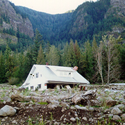
In February 1996 a series of debris flows occurred near Dodson in the Columbia River Gorge, about 35 miles east of Portland, Oregon. These flows derailed a train, and blocked both directions of Interstate 84 for five days. One of these flows passed through a house, filling the lower floor with mud and debris.
Maps, photographs, and more details on the flow are available here: HTML
Stability of Borax Lake
With Ansel Johnson, Michael Cummings and graduate student Sean Wilson. PDF
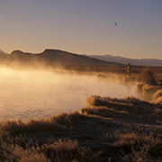
Borax lake is a hot spring located a few km from Fields in SE Oregon, in the Alvord Desert. Borax Lake is a located atop a small mound. The mound is an erosion feature -- the surrounding area has been deflated. The area around the hot spring has been armored with sinter and so now stands as a topographic high. Under the sinter is a diatomaceous material with very low remolded strength. Borax Lake contains a unique species of chub that is on the endangered species list. In order to help the chub survive water levels in the lake were raised (by damming outlets). This gives the fish a wider range of water temperatures and helps keep the average temperature more stable. Increasing the water level has also increased some spring activity on the flanks of the mound. The morphology of the mound also suggest that there is some downslope movement of the flanks.
Thus Borax lake is a saturated mound of poorly consolidated material, with very little remolded strength. Should the flanks of Borax Lake begin to move the material may remold, there would be a catastrophic loss of strength in the material, and a section of the flank could rapidly fail (i.e., within a few minutes). This would either cause the lake to drain, or the volume of water to be reduced such that there would be a significant rise in temperature. The catastrophic loss of strength could result from natural movement of the slope, or by earthquake-induced shaking.
To look for any movement on the mound we have installed a series of benchmarks which have been precisely surveyed. These monuments will be resurveyed at a later date to look for any changes in angles or distances between monuments. The monuments were laid out as a series of braced quadrilaterals. This allows us to determine the magnitude and direction of any strains. Strains of 10-3 can be detected in this way. A map of the quadrilaterals is shown below.
Engineering Geology of the Newell Canyon area, Oregon City.
With graduate student Bill Burns. PDF
This study investigated the engineering geology and relative slope stability of the southern half of Newell Creek Canyon, Oregon City, Oregon, located partially inside the urban growth boundary of Portland where there is increasing pressure for development in areas of geologically hazardous terrain.
Within the study area, features associated with landslides were mapped and categorized according to their relative age (active, inactive-young, and inactive-mature) and the depth to the failure plane (deep or shallow-seated). These features were then examined and 79 landslides were identified. Sixty-five of the slides were classified as shallow-seated or having a failure plane £ 4.5 meters below the ground surface. Most of the 14 deep-seated landslides in the study area were classified as inactive-young and inactive-mature and generally had a much greater area (1,600m2 to 256,000m2) than the shallow-seated slides (40m2 to 6,100m2).
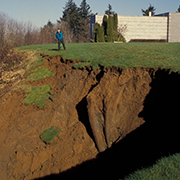
One deep-seated landslide, representative of most of the deep-seated slides, was examined in detail and a stability analysis confirmed the current, relatively stability and the potential for reactivation. The Spady Landslide, a typical shallow-seated landslide, was examined in detail by mapping the slide after its initial failure in 1996 and then again after it grew in size from 2,200 m3 to 14,600 m3 in order to examine how these types of slides grow and the resulting stability of the area immediately adjacent to these slides. Finally, a stability analysis was performed on all of the residual soils to evaluate potential shallow-seated landsliding.
From the record of landslide features and geologic conditions, the Engineering Geologic Map was constructed. This map, along with the stability analysis on existing landslides and areas with no existing features resulted in the construction of the interpretive Relative Stability Map. This Relative Stability Map was divided into three zones with the following percents of the study area: moving ground (5%), potentially unstable ground (56%), and stable ground (38%). The two maps resulting from this study along with the text serve as an engineering geologic report for use by engineers and planners in making educated decisions for future development.